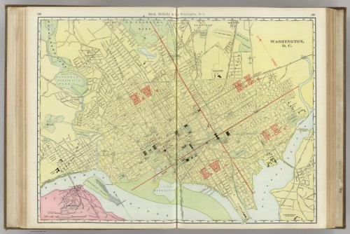
Click map to enlarge. Source: David Rumsey Map Collection
Map of the Week is written by David A., a systems librarian and map geek living in Mt. Pleasant. David previously wrote about the 1890 Real estate map of the B&O Railroad Company between DC and Rockville.
This week’s map comes from a 1903 Rand McNally atlas. By 1903, the city begins to look very familiar, though many of today’s roads do not yet appear. Rhode Island and New York Avenues stop far short of the DC border, though Rhode Island’s proposed extension appears. Notable points of interest include the Ivy City Race Track, Lover’s Lane and Analostan Island. The race track was part of the old National Fair Grounds, and it was one of many tracks built in DC in the 19th century. Lover’s Lane still bisects Dumbarton Oaks and Montrose Park north of Georgetown, and you can find it on Google Maps. Analostan Island would later be renamed for Theodore Roosevelt, the sitting president at the time of this map’s publication.
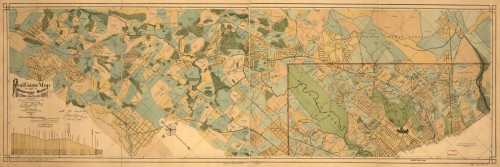
Click map to enlarge. Source: Library of Congress
Map of the Week is written by David A., a systems librarian and map geek living in Mt. Pleasant. David previously wrote about City of Washington in 1792.
Title: Real estate map of the Metropolitan Branch of the Baltimore and Ohio Railroad Company between Washington, D.C., and Rockville, Md.
This week’s 1890 map of the Metropolitan Branch of the B&O Railroad has some great detail north of the original city limits. The Metropolitan Branch of the B&O Railroad connected DC with the B&O main line in Point of Rocks, MD. Highlights include names of property owners, locations of parks, railroads and the skeletal outlines of several Maryland towns including Takoma Park, Silver Spring, Bethesda and Rockville. The Metropolitan Branch made stops in DC at New York Avenue, University (presumably Catholic University), Terra Cotta (near Ft. Totten), Lamond and Takoma.
You can see a much larger version of the map here.
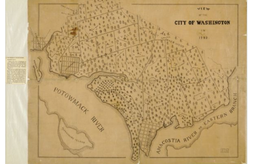
Click to enlarge. Source: Library of Congress
Map of the Week is written by David A., a systems librarian and map geek living in Mt. Pleasant.
This week’s map, published in the 1860s, depicts the area’s pre-district plantations as they might have existed in 1792. A few parcels of land bore names that carry on today: Mount Pleasant, Isherwood (Road in NE DC), but most of the place names shown here were lost to time. Most curious are the little towns of Hamburgh and Carrollsburg along the Potomac and Anacostia Rivers, respectively. Carrollsburg occupied the land around present-day Nationals Park. Hamburgh looks like it was located in present-day Foggy Bottom (the water’s edge was much further north at that time). Since the origins of this map are unknown, and it was hand-drawn many years after the time it depicts, we might not accept it as an authority on the geography of the future capital in 1792.
My favorite parcel of land is “Mexico” just west of Hamburgh where the Kennedy Center stands today. Widow’s Mite, which appears to include today’s Dupont Circle, is a close second. “
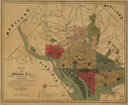
Click to enlarge. Source: Library of Congress
Map of the Week is written by David A., a systems librarian and map geek living in Mt. Pleasant.
This week’s 1887 map shows proposed routes north of the original city limits that never came to be. Like last week, we see New Jersey Avenue extending into Columbia Heights, but it appears that was only a proposed extension. Another proposal that never came to fruition was California Avenue, shown here intersecting New Jersey Avenue at the present-day intersection of Columbia Road and 12th Street. Columbia Heights never got the traffic circle promised in this map, but Grant Circle did end up being placed further north at New Hampshire and Illinois Avenues.
This map did get right the parkland that extends to Haines Point, more or less. The tidal basin looks a little different, but the dredged peninsula from the map looks very similar to what we ended up with.
Other highlights include streetcar lines, Deaf and Dumb Institute (later Gallaudet) and the Metropolitan Branch of the B&O Railroad and river depths. One of my favorite maps so far.
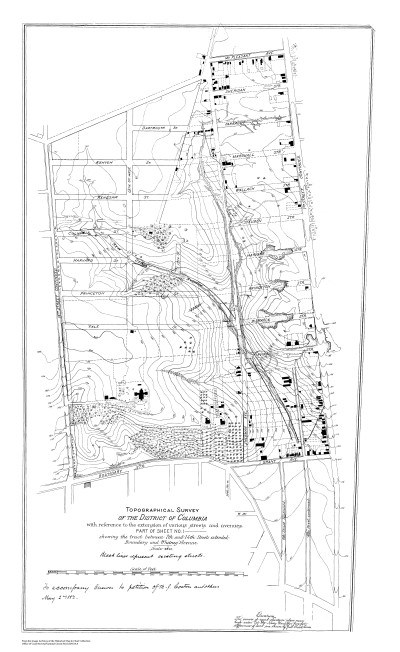
Click map to enlarge. Source: Office of Coast Survey’s Historical Map & Chart Collection
Map of the Week is written by David A., a systems librarian and map geek living in Mt. Pleasant.
This week’s map comes from NOAA’s Office of Coast Survey. DC’s east-west roads north of the lettered streets follow an alphabetic pattern from south to north. Roads further south have two syllables (Euclid, Fairmont, Girard, etc.). Once the two-syllable roads end, we get 3-syllable alphabetical names (Allison, Buchanan, Crittenden, etc.). This wasn’t always the case, and does not always hold.
One aberration from the alphabetic pattern is Columbia Road, which runs through Columbia Heights. In 1882, instead of Fairmont and Girard streets, we had Yale, Princeton, Harvard and Columbia streets. Was Columbia Street (now Columbia Road) named after the Ivy League institution like its neighbors? Or was it named for Columbian College that occupied nearby Meridian Hill? Either way, Columbia Road remains today, splitting the alphabetically correct Harvard and Irving streets.
You may be surprised to find New Jersey Avenue cutting its way through Columbia Heights. According to this map, New Jersey Avenue extended up to Columbia Road between 13th and 14th. Need to get your bearings? Present-day Florida Avenue’s distinctive curve shows up at the bottom of the map in the form of Boundary Street.
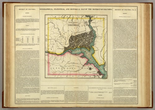
Click map to enlarge. Source: David Rumsey Map Collection
Map of the Week is written by David A., a systems librarian and map geek living in Mt. Pleasant.
This week’s map comes from the David Rumsey Map Collection, a private collection with over 37,000 digitized maps online. I urge you to check it out, as it is one of the best sources available to the public for high-resolution maps on the web.
This skewed image of DC comes from an 1822 atlas. The map shows the original 100 square mile territory of the District of Columbia. At the time, the District of Columbia included the city of Washington, George Town and Alexandria. Their populations in 1820 were 13,332, 7,360 and 8,218, respectively. Washington County occupied the northern side of the Potomac while Alexandria County occupied the southern side.
Some notable features are the numerous creeks running through DC and modern-day Alexandria and Arlington: Tiber Creek, Piney Branch, Four Mile Run, Spout Run and others. The map also includes a few roads to outlying areas named for their destinations: Bladensburg, Leesburg, Great Falls, Frederickstown, Upper Marlboro and Baltimore. Curiously, the map features only one tavern: Muds Tavern, located northwest of the city on the Turnpike Road to Frederickstown.
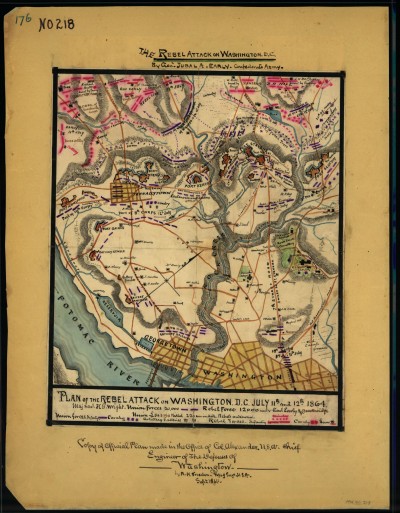
Click map to enlarge. Source, via Library of Congress, Virginia Historical Society
Map of the Week is written by David A., a systems librarian and map geek living in Mt. Pleasant.
Title: Plan of the Rebel attack on Washington, D.C., July 11th and 12th, 1864.
This week’s map is a hand-drawn, color-coded illustration of DC’s defenses late in the Civil War. Take a closer look and you will see various forts in upper NW DC arranged to defend from an attack from the north. In July of 1864, Confederate General Jubal Early approached the city from Maryland and engaged in skirmishes along the DC border before retreating to Leesburg.
Notable features include Tennallytown, Columbia College and the Aqueduct Bridge across the Potomac. Tennallytown, situated at the highest point in DC, was named for John Tennally, owner of a tavern at the corner of present-day Wisconsin Avenue and River Road. It was later shortened to Tenleytown.
Columbia College (officially Columbian College) changed its name to Columbian University in 1873 and moved to 15th St. and H st. NW. In 1904, it changed its name to The George Washington University and the institution moved to Foggy Bottom in 1912.
The nearby Aqueduct Bridge was built between Georgetown and Rosslyn with the purpose of connecting DC and Alexandria by canal. By 1864 it was repurposed as a footbridge for Union troops. The Key Bridge eventually superseded the Aqueduct Bridge, though ruins still exist near the entrance to the Capital Crescent trail in Georgetown.
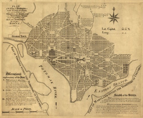
Click map to enlarge. Source: Library of Congress
Map of the Week is a new feature by David A., a systems librarian and map geek living in Mt. Pleasant.
Title: Plan of the city of Washington in the territory of Columbia: ceded by the states of Virginia and Maryland to the United States of America, and by them established as the seat of their government, after the year MDCCC
This week’s map was adapted from Pierre L’Enfant’s original vision by Andrew Ellicott in 1792. It is one of the earliest high-resolution digitized maps of DC on the web. Ellicott was originally hired to survey the new territory of Columbia and the city of Washington. Ellicott’s map includes notes on the methods for determining the lines of the city and the breadth of the streets and avenues as well as some comments on the city’s creeks. The city’s squares and circles were placed were placed “…on the most advantageous ground, commanding the most extensive prospects…” at the intersections of the city’s avenues.
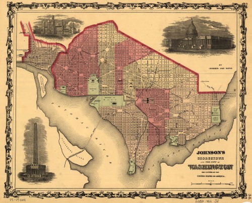
Click to enlarge. Source: Library of Congress
Map of the Week is a new feature by David A., a systems librarian and map geek living in Mt. Pleasant.
Title: Johnson’s Georgetown and the city of Washington : the capital of the United States of America
This 1862 map of Washington, DC and Georgetown was published in the midst of the Civil War. At this point in DC’s history, the Washington Canal ran down present-day Constitution Avenue, Washington Avenue and 2nd Street SE. Interesting features include various creeks running through the city and Georgetown’s original street names. Georgetown was bounded on its north edge by Road Street (present-day R Street). It remained a city independent from Washington until 1871, when the streets were renamed to conform with Washington’s lettered streets.
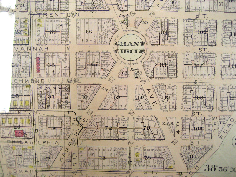
This photo is actually a bit bigger. Can you find your house?
