canvas
Click to enlarge. Source: Library of Congress

Map of the Week is written by David A., a systems librarian and map geek living in Mt. Pleasant.

This week’s map, published in the 1860s, depicts the area’s pre-district plantations as they might have existed in 1792. A few parcels of land bore names that carry on today: Mount Pleasant, Isherwood (Road in NE DC), but most of the place names shown here were lost to time. Most curious are the little towns of Hamburgh and Carrollsburg along the Potomac and Anacostia Rivers, respectively. Carrollsburg occupied the land around present-day Nationals Park. Hamburgh looks like it was located in present-day Foggy Bottom (the water’s edge was much further north at that time). Since the origins of this map are unknown, and it was hand-drawn many years after the time it depicts, we might not accept it as an authority on the geography of the future capital in 1792.

My favorite parcel of land is “Mexico” just west of Hamburgh where the Kennedy Center stands today. Widow’s Mite, which appears to include today’s Dupont Circle, is a close second. “


Columbia Hts 1

Thanks to Katie Yaeger Rotramel for sending more shots of Columbia Heights pre-DC USA. These were taken in May, 2005 on Irving Street “about a quarter block from the metro where the DSW entrance is now along with the IHOP.”

Amazing!

You can see some previous shots, also from 2005, along 14th St, NW here.

If anyone has a photo of an area/building/lot that has changed please send me an email at princeofpetworth(at)gmail with ‘Remember When?’ in the subject line. Thanks!

Columbia Hts 2


From a press release:

The Humanities Council of Washington, D.C. (HCWDC) is pleased to announce its popular House history workshops that will be held Saturday, March 30, 2013 at the Martin Luther King Jr. Memorial Library, 901 G St. NW in the Washingtoniana Division (3rd Floor). Two workshop sessions will be held: Session I: 10:00 am – 1:30 pm and Session II: 12:15 pm – 4:30 pm. This year’s House History Workshop will guide community historians, of any skill or knowledge level, through the DC Public Library Washingtoniana Division’s collections. Participants will learn how to research the history of their own home or any other historical property.

These workshops will feature presentations by professionals who will guide workshop participants on how to navigate the collection of maps, building permits database, photo archives, microfilm records and the council’s DC Digital Museum.

The House history workshops provide residents with an opportunity to explore the history of their homes including the date the home was built, architect, builder, dates of any improvements, former residents, and how the neighborhood evolved over time. House history research is powerful because it provides that personal connection to the past that few other types of historical research can; it allows anyone to forge a strong sense of connection with their neighborhood and their community whether they have called DC home for years, or just moved in last month.

Workshops are free and open to the public. Registration is required, to attend please sign up here.

Ed. Note: This very cool workshop filled up very fast last year, so be sure to register soon if interested.


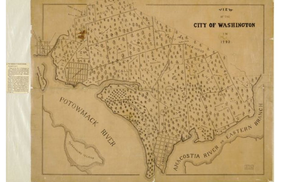
Click map to enlarge. Source: David Rumsey Map Collection

Map of the Week is written by David A., a systems librarian and map geek living in Mt. Pleasant.

This week’s map comes from the David Rumsey Map Collection, a private collection with over 37,000 digitized maps online. I urge you to check it out, as it is one of the best sources available to the public for high-resolution maps on the web.

This skewed image of DC comes from an 1822 atlas. The map shows the original 100 square mile territory of the District of Columbia. At the time, the District of Columbia included the city of Washington, George Town and Alexandria. Their populations in 1820 were 13,332, 7,360 and 8,218, respectively. Washington County occupied the northern side of the Potomac while Alexandria County occupied the southern side.

Some notable features are the numerous creeks running through DC and modern-day Alexandria and Arlington: Tiber Creek, Piney Branch, Four Mile Run, Spout Run and others. The map also includes a few roads to outlying areas named for their destinations: Bladensburg, Leesburg, Great Falls, Frederickstown, Upper Marlboro and Baltimore. Curiously, the map features only one tavern: Muds Tavern, located northwest of the city on the Turnpike Road to Frederickstown.


Streets of Washington, written by John DeFerrari, covers some of DC’s most interesting buildings and history. John is also the author of Lost Washington DC.

Recent news articles about the Washington Post’s plan to sell its headquarters building have occasionally mentioned the newspaper’s historic home, which once stood at 1341 E Street NW on Washington’s old Rum Row. While the newer building has witnessed some of the newspaper’s greatest journalistic achievements, its plain and functional architecture is a far cry from the Post’s old building, which was one of the finest and most ornate Romanesque Revival structures ever built in Washington.


The Post Building is on the left in this circa 1908 postcard (author’s collection).

The E Street building was the Post’s fourth home. The paper began in 1878 when Stilson Hutchins (1838-1912), who had previously founded the St. Louis Times, came to Washington to start up a Democratic Party organ in the Nation’s Capital. His new daily first set up shop in the former headquarters of the Washington Chronicle at 914 Pennsylvania Avenue NW but moved within a year to Jackson Hall, at 339 Pennsylvania Avenue NW, a prominent Greek Revival structure where the Congressional Globe had been printed for many years. From here, Hutchins planned the first building specially designed for the Post, at 10th and D Streets NW, which the newspaper occupied beginning in 1880.

Continues after the jump. (more…)


Outside the former Papa Razzi restaurant space at 1064-1066 Wisconsin Avenue, NW

Really easy to walk by this one. It’s across the street from the closed Ruby space in Georgetown that we spoke about yesterday.

“Bush. The old fire dog died of poison.  July 5th 1869. RIP”

From Gutenberg.org A Portrait of Old George Town:

Someone who remembers him tells me that he was a collie, and that he went to every fire along with the engine. I think the men whose companion he was, and who evidently loved him when they inscribed the “R. I. P.,” must have believed, as I do, that like the Jim in the poem of that name by Nancy Byrd Turner, he would meet them joyously “on the other side.”

And from Wikipedia about the old Vigilant Firehouse:

A stone tablet sits at ground level between the two main doorways and reads “Bush, the Old Fire Dog, Died of Poison, July 5th 1869, R.I.P.” The story was related by Cassedy:

Bush was of mixed breed, of dark brown color, a volunteer of Fire Co. No. 1. He ran with the engine to all fires and parades and was a general favorite with all who chanced to form his acquaintance. He became careless about his diet, ate free lunch between meals and was taken suddenly ill July 4, 1869. The doctors pronounced it a hopeless case of arsenical poisoning, and after several severe spasms he passed peacefully in the sixth year of his age.


Click map to enlarge. Source: Library of Congress

Map of the Week is a new feature by David A., a systems librarian and map geek living in Mt. Pleasant.

Title: Plan of the city of Washington in the territory of Columbia: ceded by the states of Virginia and Maryland to the United States of America, and by them established as the seat of their government, after the year MDCCC

This week’s map was adapted from Pierre L’Enfant’s original vision by Andrew Ellicott in 1792. It is one of the earliest high-resolution digitized maps of DC on the web. Ellicott was originally hired to survey the new territory of Columbia and the city of Washington. Ellicott’s map includes notes on the methods for determining the lines of the city and the breadth of the streets and avenues as well as some comments on the city’s creeks. The city’s squares and circles were placed were placed “…on the most advantageous ground, commanding the most extensive prospects…” at the intersections of the city’s avenues.


Click to enlarge. Source: Library of Congress

Map of the Week is a new feature by David A., a systems librarian and map geek living in Mt. Pleasant.

Title: Johnson’s Georgetown and the city of Washington : the capital of the United States of America

This 1862 map of Washington, DC and Georgetown was published in the midst of the Civil War. At this point in DC’s history, the Washington Canal ran down present-day Constitution Avenue, Washington Avenue and 2nd Street SE. Interesting features include various creeks running through the city and Georgetown’s original street names. Georgetown was bounded on its north edge by Road Street (present-day R Street). It remained a city independent from Washington until 1871, when the streets were renamed to conform with Washington’s lettered streets.


View More Stories