snow-cop

From a press release:

“Today, Mayor Muriel Bowser, Department of Public Works (DPW) Director Christopher Shorter, District Department of Transportation (DDOT) Director Leif Dormsjo, Director of the District of Columbia’s Homeland Security and Emergency Management Agency (HSEMA) Chris Geldart, Serve DC Director Delano Hunter, and DC General Services (DGS) Acting Director Greer Gillis kicked off the District’s 2016-2017 snow season with a snow dry run practice session and a citywide winter exercise.

“Today, we put our planning, procedures and equipment to the test,” said Mayor Bowser. “This dry run ensures our snow team is staffed, trained, equipped and ready for winter. We’re ready for snow, but hoping for none.”

This year’s Snow and Ice Removal Program features: (more…)


wet
Photo by PoPville flickr user Mr.TinDC

From the National Weather Service:

“FLASH FLOOD WATCH FROM 6PM EDT WED UNTIL 8AM EDT FRI

… FLASH FLOOD WATCH REMAINS IN EFFECT INTO FRIDAY MORNING…

THE FLASH FLOOD WATCH CONTINUES FOR

* PORTIONS OF MARYLAND… THE DISTRICT OF COLUMBIA… VIRGINIA AND WEST VIRGINIA… INCLUDING THE FOLLOWING AREAS… IN MARYLAND… ANNE ARUNDEL… CALVERT… CARROLL… CENTRAL AND EASTERN ALLEGANY… CENTRAL AND SOUTHEAST HOWARD… CENTRAL AND SOUTHEAST MONTGOMERY… CHARLES… FREDERICK MD… NORTHERN BALTIMORE… NORTHWEST HARFORD… NORTHWEST HOWARD… NORTHWEST MONTGOMERY… PRINCE GEORGES… SOUTHEAST HARFORD… SOUTHERN BALTIMORE… ST. MARYS AND WASHINGTON. THE DISTRICT OF COLUMBIA. IN VIRGINIA… ALBEMARLE… ARLINGTON/FALLS CHURCH/ALEXANDRIA… AUGUSTA… CENTRAL VIRGINIA BLUE RIDGE… CLARKE… CULPEPER… EASTERN LOUDOUN… FAIRFAX… FREDERICK VA… GREENE… KING GEORGE… MADISON… NELSON… NORTHERN FAUQUIER… NORTHERN VIRGINIA BLUE RIDGE… ORANGE… PAGE… PRINCE WILLIAM/MANASSAS/MANASSAS PARK… RAPPAHANNOCK… ROCKINGHAM… SHENANDOAH… SOUTHERN FAUQUIER… SPOTSYLVANIA… STAFFORD… WARREN AND WESTERN LOUDOUN. IN WEST VIRGINIA… BERKELEY… EASTERN MINERAL… HAMPSHIRE… HARDY… JEFFERSON AND MORGAN.

* INTO FRIDAY MORNING

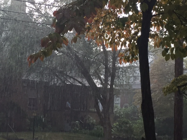
* A POWERFUL LOW PRESSURE SYSTEM OVER THE MIDWEST WILL BRING PERIODS OF HEAVY RAIN TO OUR AREA THROUGH THURSDAY NIGHT.

* WIDESPREAD RAINFALL AMOUNTS OF 4 TO 8 INCHES ARE EXPECTED. LOCALIZED AMOUNTS UP TO A FOOT OF RAIN ARE POSSIBLE… INCLUDING ALONG THE EASTERN SLOPES OF THE NORTHERN VIRGINIA BLUE RIDGE AND CATOCTIN MOUNTAIN IN MARYLAND.

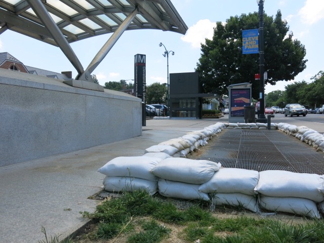
PRECAUTIONARY/PREPAREDNESS ACTIONS…

THESE NEXT FEW DAYS WILL BE A DANGEROUS TIME… REQUIRING MORE THAN THE USUAL AWARENESS… PLANNING AND PREPARATIONS.

IF YOU ARE NEAR STREAMS OR DRAINAGE DITCHES… KEEP AN EYE ON THEM AND BE READY TO QUICKLY SEEK HIGHER GROUND. WATER MAY RISE RAPIDLY.

CLEAR OUT STORM DRAINS.

THOSE PRONE TO BASEMENT FLOODING SHOULD PREPARE. COMMUNITIES PRONE TO FLOODING SHOULD PREPARE.

CONTINUE TO CHECK IN ON THE FORECAST FOR UPDATES. (more…)


raining

Hard. Updates when more info is available.

Update:

“NWS has issued a Severe Thunderstorm Warning for Washington DC. A storm with wind gusts of over 60 MPH and quarter sized hail is currently in Bethesda. It is moving south at 20 MPH (into the District). Please head indoors. Be ready to pull over if driving.


spray-park
Photo by PoPville flickr user Victoria Pickering

From DPR:

“Due to the expected high temperatures for the remainder of the week, the DC Department of Parks and Recreation (DPR) will keep the District Spray Parks open for an additional week. Spray Parks were scheduled to close on Monday, September 5 at 7 pm. The following spray parks will extend hours of operation until Sunday, September 11 at 7 pm. (more…)


tree down pub
1648 North Capitol St, NW

Remember that tree that went down in front of Pub and the People last week? You gotta see the video! Thanks to P&P for sending:

“Our server Walter nearly being decapitated by the tree last week. We’re updating training to tell all employees umbrellas aren’t worth risking their lives.”

Walt v. Tree (Bar Front)

Two more videos after the jump. (more…)


flood

From Alert DC:

“The National Weather Service has issued a severe thunderstorm watch for the entire Washington DC area from now until midnight. Damaging winds are the primary threat. An isolated tornado is possible. Please clear drains and catch basins, and remove light objects from porches. Seek shelter in an inner most room or basement in case of a tornado.”

and

“THE NATIONAL WEATHER SERVICE HAS ISSUED A FLASH FLOOD WATCH FOR THE DC METRO AREA FROM NOW UNTIL 11 AM JULY 29, 2016. SHOWERS AND THUNDERSTORMS WILL BE CAPABLE OF PRODUCING TORRENTIAL DOWNPOURS WITH RAINFALL RATES OF AN INCH OR TWO PER HOUR AT TIMES.”


View More Stories