
PoPville flickr user annejuliet found this one. I assume it’s somewhere near Capitol Hill?

PoPville flickr user annejuliet found this one. I assume it’s somewhere near Capitol Hill?

It’s been a while since I’ve seen one of these signs from the African American Heritage Trail. I love imagining what these homes/neighborhoods were like 100 years ago.

I’d never heard of Mr. Cromwell and found the info particularly interesting:


You can read Vaughn and Amelia’s first journey here and second journey here.
On Sunday, November 22, after a two-month hiatus, we resumed our trek around the DC border. We stuck to the original boundary, which adheres to Article I, Section 8, Clause 12 of the U.S. Constitution, setting aside a 10 mile square for the nation’s capital (so said one of the historic marker signs, though it seems to actually be Clause 17: http://www.house.gov/house/Constitution/Constitution.html). Having already covered the NE and SE quadrants, this time we found ourselves covering the SW perimeter, technically Virginia these days. The land south of the Potomac used to belong to Virginia, became part of DC following the Revolutionary War, and was returned to Virginia by Congress in 1846.
Because the SW boundary is no longer a DC border, this was not the most “as the crow flies” walk. However, King St. functioned somewhat as our guiding road, as Eastern Ave. did for the NE border and Southern Ave. did in SE.
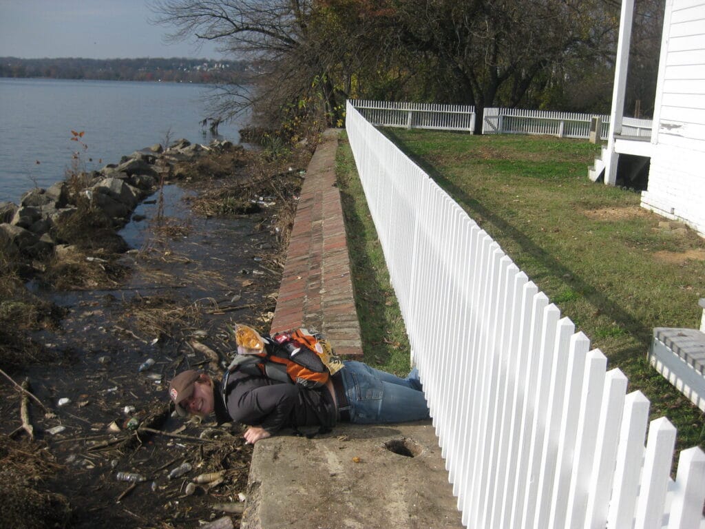
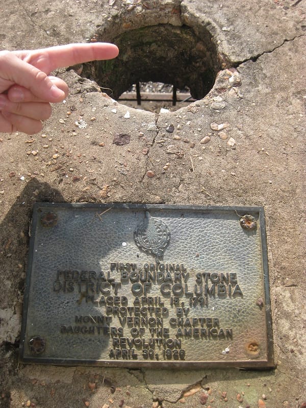
The trek started out on a decisive high point, as the first stone is tucked in the middle of the retaining seawall of the Jones Point Lighthouse. The stone is much more interesting than the dinky lighthouse, and can either be viewed through a round hole bored through the top of the wall, or by lying on one’s belly, hanging over the edge, and peering at the stone upside down through a gate.

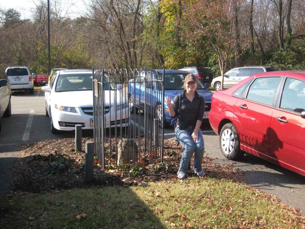
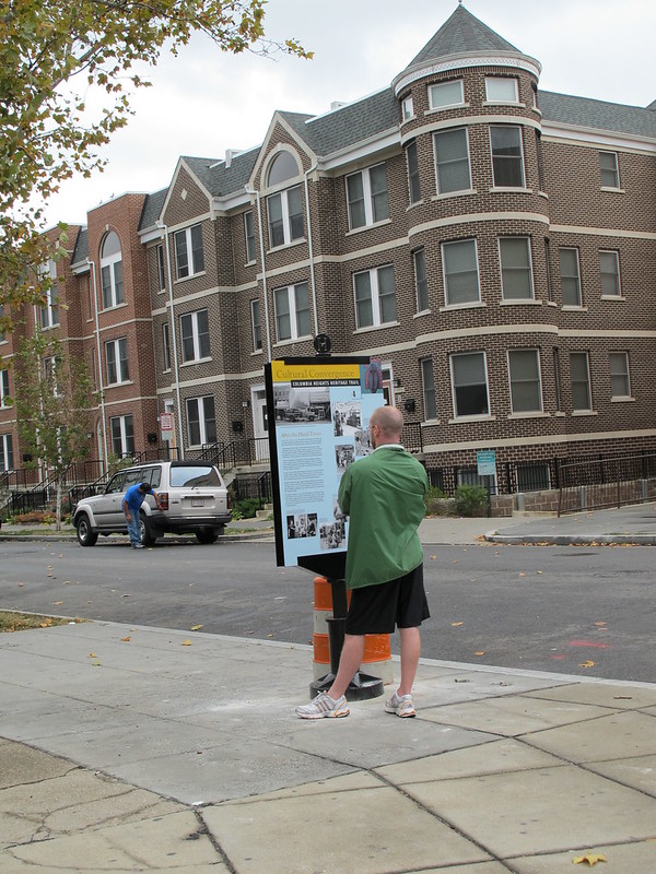
What sets these ten stones apart from the other quadrants is the signage. Virginia loves to surround its boundary stones with signs. Although most of the stones were not in their original locations, had been hit by cars, and/or run over by plows, the plaques for each stone were much better preserved than on our previous two walks. Winning the title of cheesiest sign on the walk and hung next to a stone in a school parking lot, a groan-worthy saying contrasts Arlington’s old limits with its students’ boundless horizons.

Stay tuned for the final quadrant, and a special guest trekker- PoP!
Items of note:
– At a couple points throughout the walk, we saw signs for the Virginia Bird and Wildlife trails. Curiously, the signs feature a picture of a mountain, a bird, and a bear. We ask you: How many wild bears are there in NoVa? And why willingly take a stroll along a path with prominent advertisements for bears?
– Each stone is preserved by a different chapter of the Daughters of the American Revolution: Mt. Vernon Chapter, Colonel John Washington Chapter, Keystone Chapter, Dr. Elisha Dick Chapter, Fairfax County Chapter, etc.
– Despite the prolific signage, SW-9 is the only stone that dons an official “National Historic Landmark” marker, although they are all federal monuments. The sign reads, “This site possesses national significance in commemorating the history of the United States of America.” – 1980, Heritage Conservation and Recreation Service, United States Department of the Interior
– This quadrant proved to have the most quaint houses and neighborhoods and didn’t make us play frogger across any highways. However, we did have to walk on a sidewalk set in the median of a busy road, and one of the stones was even set in a median!
By the numbers:
Stones found: All 10!
Times children screamed “Jesus loves you!” out their car window at us: 1
VA Bird and Wildlife Trail signs (with bears on them): 2
Discarded mattresses: 0
American flags on houses: too many to count


Danny Harris is a DC-based photographer, DJ, and collector of stories. In September, he launched People’s District, a blog that tells a people’s history of DC by sharing the stories and images of its residents. Every day, People’s District presents a different Washingtonian sharing his or her insights on everything from Go Go music to homelessness to fashion to politics. You can read his previous columns here.
“I was born in France and came to the United States in 1960. I came because I had a sister in North Carolina who suffered a tragic accident. I ended up in Washington because I had a friend here. Thirty years ago, my husband and I bought the Catania Bakery. Neither my husband nor I were bakers, but Grace Caruso, the former owner, taught me everything I know. For the last thirty years, we kept the place just as they did. We still make Italian breads using Grace’s recipes and deliver them to restaurants around the District, Maryland and Virginia.
“Back in 1932 when the Catania Bakery opened, there were Italian stores all along North Capitol Street. This was an Italian neighborhood. The Carusos used a wood burning over and delivered traditional Italian breads door-to-door. Most of the community here was from Southern Italy so it was the bread they knew from home. The Caruso family came from Nicolosi, which was at the base of Mt. Etna. Catania, the name of this bakery, is the name of the province in Sicily where Nicolosi is. You know the Italians, they can’t live without their bread so this place was a staple of the neighborhood. Now, most of the Italians are no longer here, they either died or went down south, but a few of them are still around. This bakery is the last remnant of Italian life on North Capitol Street. The Italians living around here and coming by are mostly older people. The newer Italian generation is more Americanized, but they will still come in on holidays to get some of our bread because they grew up eating at this bakery. We also do events with the Knights of Columbus, the Holy Rosary, Catholic Churches, and we used to do the bread for the big Italian convention in DC.
“The neighborhood started changing after World War II and becoming less Italian. Due to a number of reasons, the neighborhood really got bad. When we first bought the place in the late 1970’s, I never came at night because the neighborhood was so dangerous. It got better, but it is still a very dangerous place. We have children, but they are not involved with the bakery. Because of this area, my husband was not keen on having our children or grandchildren come here. We’ve had a number of robberies, some of them were big time robberies. My granddaughter used to come down and spend Saturday’s here with me ever since she was three-years-old. But, she was here during a robbery and her parents wouldn’t let her come down anymore. Now, I am here by myself. Danger is still here. But, we have been here for a long time and will stay. We are resilient. The neighborhood is getting better, but that doesn’t mean the bad elements are gone. At night, you wouldn’t want to walk around by yourself, but, the neighborhood is slowly changing with new families. Because of that, on Saturday’s, I started making and selling croissants out of the bakery. That is my French addition to this old place. Otherwise, it is and will remain Italian. You know, after all of this time here, I feel more Italian than French!”
Catania Bakery is located at 1404 North Capitol Street NW.
Just saw this from MPD:
“On November 13, 2009, at approximately 2200 hours, an accident occurred at 13th & Girard Streets, NW. The driver in this case struck a total of 6 cars, including four parked cars and two that were occupied. The driver of the striking vehicle suffered a broken leg and one other person was taken to the hospital with non-life threatening injuries. It was discovered that the striking vehicle was stolen and the driver of that vehicle, a 15-year old male, was apprehended and placed under arrest for a number of felony and traffic charges.
The officers handling the scene were Third District Officers Jonathan Amigo, Thomas Dunn, Jesus Perez, Jared Rothman, William Hamm, and MPO Darryl Arrington.”
These incidents sadly seem to be relatively common on 13th Street.
On a related note when I did a quick search of 13th and Girard I found this great historical photo from Flickr User rockcreek:

He writes:
“A slightly blurry shot of the Army and Navy Academy – a prep school – at 13th and Girard (then Princeton) Streets, NW. From A Statement of Some of Advantages of Beautiful Columbia Heights (1904).”


Ever since posting the before and after photos from Columbia Heights I love the seeing other before and after shots. At the Urban Land Institute lecture, I mentioned earlier, there was a discussion on the past and future of U Street. There was a discussion with
• Jair Lynch, President & CEO, Jair Lynch Development Partners (Moderator)
• Paul Robertson, President, Robertson Development
• David Franco, Principal, Level 2 Development
• Josh Dix, Vice President, PN Hoffman
They mostly talked about the projects they had worked on in the area. It was very interesting but what I found most fascinating was the before and after photos which they were kind enough to share with me. One more item of note though, was that when asked what they saw the future looking like, they mentioned that they expected development to continue up 14th Street to Columbia Heights. They also mentioned that construction at the old Nehemiah Shopping Center site is slated to begin in the Fall of 2010.
So, above you can find what the current View 14 space looked like. Below is what it looks like now:

After the jump you can see before and after photos from Solea across the street from View 14 at the corner of 14th and Florida. Also after the jump you can see a before and after photo of Union Row at 14th and W. (more…)

The Columbia Heritage Trail unveiling was a great success and managed to beat the rain on Saturday afternoon. The turnout was spectacular. Kojo Nnamdi from WAMU (88.5) was the emcee and there were speeches by Ward 3 Council Member Mary Cheh and Ward 1 Council Member Jim Graham (among others).

Kojo Nnamdi once caught a fish…
The festivities took place at the new Columbia Heights Plaza and the actual unveiling took place just south on 14th St. in front of The Heights restaurant:

CM Mary Cheh third from left, CM Graham’s dog at bottom

Signs are are up and down 14th Street and other spots as well (one is outside of Wonderland). You can find a complete map of the trail here.


600 block of Columbia Road, NW
Ever since I asked folks about what ethnic restaurant their neighborhood was missing, I’ve been keeping my eyes peeled for delis (since they were mentioned a few times). I noticed Jack’s Delicatessen located on the 600 block of Columbia Road, NW not far from Georgia Ave. I’m wondering if any of the long term residents remember this spot? Do you think a deli located on a residential block like this could do good business?

Above’s photo is from the Library of Congress, and shows the Arcade Market, which used to stand on the site that is now DCUSA. Press release from an email:
“A neighborhood that began as an elite suburb on the high ground above Washington has since hosted every group of people that ever influenced Washington’s cultural life. This story and many more are told on Cultural Tourism DC’s Cultural Convergence: Columbia Heights Heritage Trail. On this self-guided walking tour, 19 poster-sized street signs combine storytelling, photography, and maps to lead residents and visitors through old and new Columbia Heights, introducing the people who changed the world with technology, ideas, literature, laws, and leadership.
The Columbia Heights Heritage Trail’s official unveiling and neighborhood celebration will take place Saturday, October 24. Councilmembers Jim Graham and Mary Cheh will join Cultural Tourism DC and the Columbia Heights Heritage Trail Working Group for the 1 pm ceremony on Civic Plaza (14th Street and Park Road, NW). WAMU’S Kojo Nnamdi will emcee and celebrated DC author Marita Golden will speak about how the Columbia Heights neighborhood influenced her writing. Continues after the jump (more…)

Thanks to PoPville twitter follower Joeon11thDC for alerting me to this awesome sign.
Routes change Feb. 19, 1978. Too good. I shoulda made this a caption contest…