
Been a while since I spotted a good one. I don’t think I’ve ever seen a better ‘2’ before.


Been a while since I spotted a good one. I don’t think I’ve ever seen a better ‘2’ before.

If you have a photo of a neat find from your house or place of work please send an email to princeofpetworth(at)gmail.com thanks.
This attic hit pay dirt. Thanks to a reader for sending from Petworth/Brightwood.


Update: Tomorrow’s practice flight has been postponed due to weather.
From a press release:
“WHAT: Arsenal of Democracy Flyover Practice Flight
WHEN: Tuesday, March 10, 2015, at 12:10 p.m.
WHERE: Along the National Mall, Washington, D.C.
DETAILS: On March 10, 2015, residents of Washington, D.C., and neighboring counties may observe a twin-engine private aircraft flying in the vicinity of the Potomac River and along the National Mall. This aircraft will be conducting a practice flight to assist with planning for the Arsenal of Democracy Flyover commemorating the 70th Anniversary of Victory in Europe Day, scheduled for May 8, 2015.
The aircraft will depart Manassas Airport and fly to the Leesburg area, then down the Potomac River near the National Mall. It will then fly south until well south of the Washington, D.C. area. The aircraft will be near the National Mall for a few minutes at 12:15 p.m. on March 10. It will be flown by a qualified pilot and will adhere to all Federal Aviation Regulations. This event has been extensively coordinated with the FAA, TSA, and Secret Service, and official authorization has been granted for this flight. Minimum altitude will be 1,000 ft.
About the Arsenal of Democracy Flyover: The Arsenal of Democracy: WWII Victory Capitol Flyover is scheduled to take place on Friday, May 8, 2015 in Washington, D.C. Beginning at approximately 12:10 p.m., a diverse array of World War II aircraft will fly along the National Mall in historically sequenced warbird formations representing the War’s major battles, from Pearl Harbor through the final air assault on Japan, and concluding with a missing man formation to “Taps.” This historic event is being planned to honor the heroes who fought in the Warand those on the home front who produced the tanks, ships, and aircraft that enabled the U.S. and its Allies to achieve victory.”

From an email:
“Thursday, March 5, 6:30 pm – Washingtoniana Division, Martin Luther King Jr. Library, 901 G Street, NW
Sunday, March 8, 3 pm – Mount Pleasant Library, 16th and Lamont Streets, NW
Mapping Segregation in Washington DC is a research project whose goal is to create a set of layered, online maps illustrating the historic segregation of DC’s housing, schools, recreational facilities, and other public venues. Our first year has been focused on racially restrictive housing covenants mostly east of Rock Creek Park, and the legal challenges to them.
Come learn why many of DC’s “historically black” neighborhoods were once exclusively white, and how more recent shifts in the city’s racial identity have been shaped by this history.
Come see for yourself the maps we’ve created to show restricted neighborhoods, the legal battle lines, and who lived where over the years. Maps tell stories that words cannot.
Mapping Segregation in Washington DC is a collaboration among historians Mara Cherkasky and Sarah Shoenfeld of Prologue DC, historian/GIS specialist Brian Kraft of JMT Technology Group, and others. It is funded in part by the Humanities Council of Washington, DC.”


Today:

If you have a photo of a neat find from your house or place of work please send an email to princeofpetworth(at)gmail.com thanks.
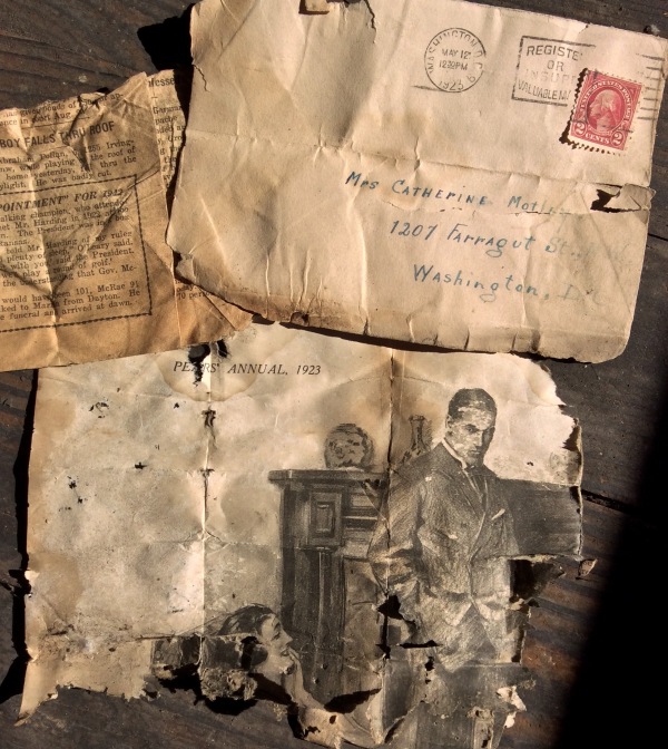
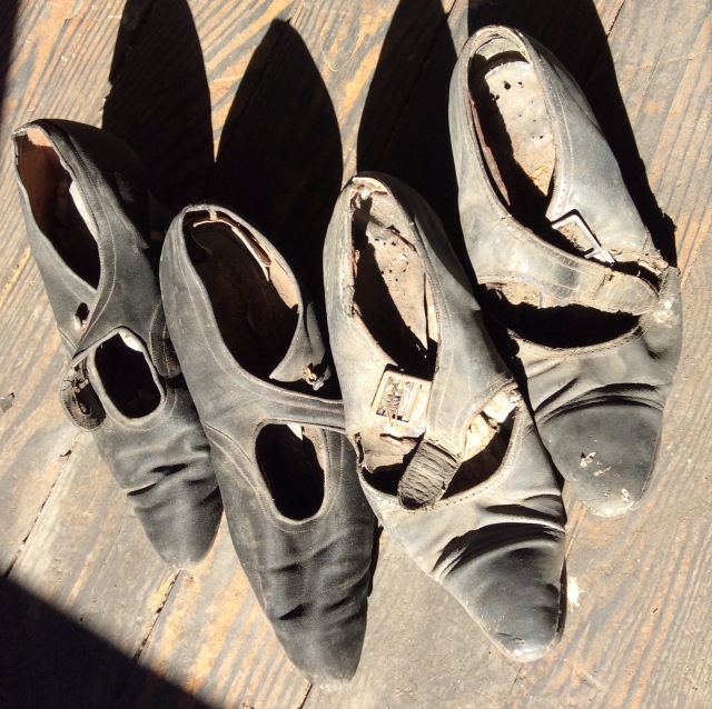
“Women’s shoes found in attic eaves. Newspaper and envelope dated 1923 found stuffed inside of shoes. Discovered these shoes a few years ago when I was looking for squirrels.”
I’m seriously loving this feature so if you have a photo of a neat find from your house or place of work please send an email to princeofpetworth(at)gmail.com thanks.

“I found this in my basement in a cabinet next to the fuse box. It is a promotional item from Cavalier Liquor Shop. We think it used to hold a calendar, long pulled off the cardboard.
The thermometer still seems to work. And it does have an awesome phone number: TUckerman 2-2142”

Ed. Note Cavalier Liquor still kicking today.


I’m seriously loving this feature so if you have a photo of a neat find from your house or place of work please send an email to princeofpetworth(at)gmail.com thanks.
A reader writes:
“In 2001, my parents put an addition on their Cleveland Park home. The Macomb St. house was built in 1914. While the backyard was being dug up, I found this half pint Shoomaker’s whiskey bottle half buried in the ground. Shoomaker’s, which closed at the start of Prohibition, is the birthplace of the Rickey.”

I have to admit, I’m loving this feature, if you have a photo of a neat find from your house or place of work please send an email to princeofpetworth(at)gmail.com thanks.
A reader writes:
“I bought a house in Anacostia few years ago and one of the features that I found interesting was a toilet located on the rear exterior of the house. Is this common for dc?”
Ed. Note: Back in 2008 a reader also found one in Petworth.

I have to admit, I’m freaking loving this new feature, if you have a photo of a neat find from your house or place of work please send an email to princeofpetworth(at)gmail.com thanks.
This might be my favorite one yet:
“Gunther’s beer Premium Dry Lager
Packed at the Brewery by Gunther Brewing Co. Inc., Baltimore MD
Tax paid at the rate prescribed by Internal Revenue
Flat top – requires churchkey to open
I believe this can was buried behind my bathroom walls in 1947 when the house was built (Shepherd Park). Which matches the date range for the tax label (required on cans filled before March 1950). The Gunther brewery building still exists in B’more – turned into apartments!”