
First up this season – the great Bartholdi fountain on the Hill.


First up this season – the great Bartholdi fountain on the Hill.

Photo by PoPville flickr user Eric P.
It may get to 75 degrees today but the snow will, possibly/hopefully, come eventually.
From a press release:
“On Friday, Mayor Muriel Bowser and DC Snow Team leaders will kick off the 2015-2016 snow season at the Dry Run press conference. The Snow Dry Run is a training exercise for the 800+ members of the DC Snow Team (Department of Public Works, DC Department of Transportation and other agencies) to prepare for snow fighting duties, proper handling of materials, proper maintenance of equipment, and proper operation of the equipment. About 700 plow drivers will drive their routes, leaving from their assigned staging yards, while administrative, supervisory, logistics and IT employees will practice their functions at their sites, including the salt domes.
Mayor Bowser will also call on residents to join the District’s Resident Snow Team, a volunteer program run by Serve DC that connects volunteers with elderly and disabled residents who need assistance shoveling walkways during the winter.”

100 block of Rhode Island Ave, NW in 2012
From DC Water:
“In preparation for severe weekend weather and potential impacts from Hurricane Joaquin, DC Water is ramping up staffing and taking other actions to protect its customers, facilities and personnel. DC Water is closely monitoring flood-prone areas of the District of Columbia and crews are working around the clock to clear storm drains and prepare pump stations for increased flows. Emergency equipment and staff are standing by to respond to problems that may occur as a result of the storms.
DC Water is prepared to distribute sandbags to customers that live in the flood-prone neighborhoods of Bloomingdale, LeDroit Park and the 900 block of P Street NW. DC Water personnel will staff a sandbag distribution location for residents of the targeted neighborhoods at First Street and Rhode Island Avenue NW beginning today at 10:00 am. Please note that sandbags will only be distributed to residents in these targeted neighborhoods and they may be asked to show proof of residency at the distribution site.”
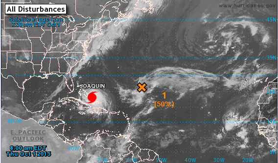
Via NOAA
From the Mayor’s Office:
“Yesterday, Mayor Bowser was briefed by the District’s Homeland Security & Emergency Management Agency (HSEMA) and District leadership on the forecast for Hurricane Joaquin and the District’s preparedness. HSEMA is holding twice daily briefings with the National Weather Service and agency directors on storm preparation.
This morning, Mayor Bowser hosted a call with HSEMA and senior leadership to discuss the District’s efforts.
Starting Friday at 4:00 PM, the District will ramp up response operations at the Emergency Operations Center (EOC) at HSEMA.
The Bowser Administration will continue to monitor the weather events, provide updates to the public and evaluate assets for the preparedness and response operations.”
The Post’s Capital Weather Gang report:
“Though key details on the final track of the powerful hurricane remain in question, one thing does look certain: extreme rainfall totals are likely for large parts of the Eastern Seaboard, if the storm tracks close to the coast or inland.”
Though they note the National Hurricane Center reports:
“Confidence in the details of the forecast after 72 hours remains low, as there have been some large changes in the model guidance overnight. The range of possible outcomes is still large, and the possibility of a hurricane landfall in the Carolinas still cannot be ruled out.”

Photo by PoPville flickr user Bossi
From the Washington Post‘s Capital Weather Gang:
“As of 8 a.m., Joaquin is now a hurricane with maximum sustained winds near 75 mph and expected to strengthen. Although many models have now converged on a Saturday night-Sunday landfall somewhere between North Carolina and New Jersey, last night’s European model (one of the most trusted) still has Joaquin staying out to sea. As described below, the D.C. area is in line for a serious rain threat Friday through Sunday regardless of the track of Joaquin. A direct hit on the mid-Atlantic, with extreme wind locally in addition to potentially flooding rain, is one possible scenario.”

Photo by PoPville flickr user Lorie Shaull

Photo by PoPville flickr user Jim Havard

Photo by PoPville flickr user John Sonderman

Photo by PoPville flickr user nevermindtheend

Photo by PoPville flickr user Brett Bowers

Photo by PoPville flickr user Nikoo Yahyazadeh
Thanks to Pablo for sending this depressing news from Science Daily – Washington, DC sinking fast, adding to threat of sea-level rise:
“This falling land will exacerbate the flooding that the nation’s capital faces from rising ocean waters due to a warming climate and melting ice sheets–accelerating the threat to the region’s monuments, roads, wildlife refuges, and military installations.”
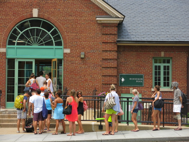
From DPR:
“Due to high temperatures, DPR has extended the operating hours at select District pools until 8 pm today.
The following pools will extend hours of operation until 8 pm:
Ward 1
Banneker Recreation Center Pool
2500 Georgia Avenue, NW
Ward 6
Rosedale Pool
1701 Gales Street, NE
Ward 8
Anacostia Pool
1800 Anacostia Drive, SE
Ward 2
Francis Pool
25th & N Street, NW
East Potomac Pool
972 Ohio Drive SW
Ward 7
Fort Dupont Pool
830 Ridge Road, SE
Pools that are not listed will operate on their normal, individualized operating schedules.”

Photo by PoPville flickr user Melanie Cohen
From AlertDC:
“National Weather Service has issued a Severe Thunderstorm Watch for the Washington Metro Area from 2:25pm today until 9pm tonight. Damaging wind gusts and large hail are the primary possible threats. Please use precaution.”
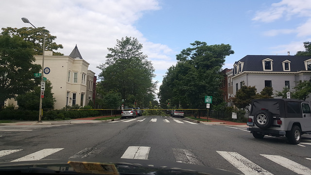
Thanks to a reader for sending around 9am. Anyone else see trees down around town?