Photo by PoPville flickr user philliefan99

From the Mayor’s Office:

I agree with Chief Lanier that as our city grows we must make further investments in public safety. I’ve recently proposed adding 100 officers to the ranks of the Metropolitan Police Department (MPD) to give the Chief the ability to deploy additional officers into our communities on foot, bike, and Segway – especially in neighborhoods that are growing rapidly. I strongly believe that adding these additional officers is critical to keeping our residents and visitors safe, and I’m deeply disappointed that the Council is considering opposing this plan. I urge the Council to reject this ill-advised and short-sighted maneuver, and join with me in working to make our city the safest it can be.

Mayor Vincent C. Gray

Attached is a letter from MPD Chief Lanier advocating for increased resources.

December 17, 2012

The Honorable Phil Mendelson, Chairman
Council of the District of Columbia

1350 Pennsylvania Avenue, NW
Washington, DC 20004

Dear Chairman Mendelson:

As we are about to embark on another year, I am reminded that we must be prepared to face the critical challenges that will soon be upon us. Like many other urban areas, Washington, D.C., is experiencing a staggering amount of economic development and population growth.

This welcome growth means more areas of shopping, restaurants, offices, and residences, all of which will require expanded police attention. We must undertake prudent planning as this development is occurring to ensure We are in the best possible position to handle those future challenges and continue to provide the high quality police service the community has come to expect from us.

During the past year, we have conducted a comprehensive analysis of ongoing development throughout the city. The historical lessons We have learned from areas such as Chinatown and Columbia Heights suggest that several other areas of development will experience an upward trajectory in Workload – both calls for service and crime. Capitol Riverfront and NoMA have both experienced incredible growth, yet continued plans suggest they are merely in the early to mid-stages of development. Several other areas – including the H Street corridor, U Street and 14th Street NW, CityCenterDC, DuPont Circle, Adams Morgan, and the St. Elizabeth’s campus, to name a few – are undergoing substantial amounts of new or continued development. All of these areas will have a significant impact on police services. Our analysis has made it clear that due to the dense development, the areas will demand a different type of police deployment- more foot, bike, and Segway patrols, which are not able to cover as large of an area.

To highlight the real impact of the city’s rapid economic development, I share with you one example of what We have learned. We have determined that when a new bar opens, city blocks with 10 or more ABRA establishments require four times the additional manpower than blocks with one to nine bars. There are 17 city blocks that currently have 10 or more ABRA locations. More notably, there are 10 additional city blocks that are within one or two new bars of reaching the 10-bar tipping point. The fact is Washington is no longer merely a day-working, commuter city. It is a 24/7 city filled with a thriving and growing nightlife.

Continues after the jump. (more…)


Photo by PoPville flickr user Mr. T in DC

From Capital Bikeshare:

The District Department of Transportation today announced proposed locations for 54 new Capital Bikeshare stations to be installed this winter in the District of Columbia. The list includes proposed new stations in all 8 wards of the city.

“These new locations will mean a 40% increase in the number of CaBi stations in DC,” said DDOT Director Terry Bellamy. “Combined with new stations in Arlington, Alexandria and soon in Montgomery County, we’re building a robust and truly regional system.”

There are currently 138 stations in DC, 45 in Arlington, and 8 Alexandria.

DDOT selected the 54 locations from a longer list of 78 suggested locations submitted by the public over the past 2 years. DDOT evaluated the locations using several criteria, including population density, employment density, bike-to-work rate, proximity to metro, and proximity to other Bikeshare stations. Residents also ‘voted’ for their preferences using an interactive crowdsourcing map.

The proposed stations are in a mix and new and existing bikeshare neighborhoods. “We need to balance the desire to expand into new areas with the need for more docks and bikes in existing areas, particularly downtown, where demand is heaviest.” said Chris Holben, DDOT Project Manager for Capital Bikeshare. “Basically, for every ‘expansion’ station we also need more spaces downtown to keep up with demand.”

DDOT plans to start installing new stations and bikes in January and finish in March. Locations not selected in this round of 54 will be considered for the next round. The complete list is below. You can also view the proposed locations alongside existing stations on a map at http://goo.gl/maps/UJPZs.

To comment on the list of proposed locations, please email [email protected] by January 15, 2013.

Full list after the jump. (more…)


Click to enlarge

From an email:

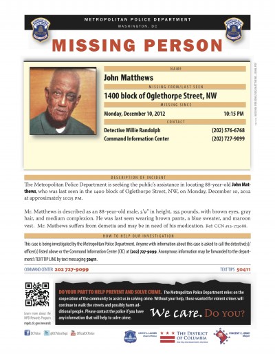
The D.C. Metropolitan Police Department has sent out an alert on a vulnerable senior who has been missing since last night (12.10) from the 1400 block of Oglethorpe Street, NW. John Matthews is described as an 88-year-old male, 5’9” in height, 155 pounds, with brown eyes, gray hair, and medium complexion. He was last seen wearing brown pants, a blue sweater, and a maroon vest. Mr. Mathews suffers from dementia and may be in need of his medication.

Anyone with information about his whereabouts may contact the COMMAND CENTER at 202 727-9099 or TEXT TIPS 50411.

matthews_john


From a press release:

Mayor Vincent C. Gray and D.C. Taxicab Commission (DCTC) Chairman Ron M. Linton introduced a vehicle exhibit at the Verizon Center to display four proposed color schemes for the District’s taxicab fleet. The exhibit is the next step in moving towards a standardized uniform color scheme for the D.C. taxicab industry – a critical aspect in the implementation of upgrades to the industry mandated by the Taxicab Modernization Act.

Additional proposed color schemes will be posted on the DCTC website to generate further public feedback. The responses will be incorporated in the decision-making process along with comments from an upcoming public hearing as well as meetings with D.C. taxicab owners and operators. Final recommendations are expected by the spring of 2013.

Continues after the jump. (more…)


View Larger Map

From a press release:

Mayor Vincent C. Gray today announced the formation of the Walter Reed Community Advisory Group and launched four Great Streets grant programs to assist revitalization of commercial corridors – two in the area of the former Walter Reed Army Medical Center and two in other parts of the District.

Building on the foundation created through years of planning by the citizen members of the Walter Reed Local Redevelopment Authority Committee, the Community Advisory Group will work with the District as it transitions into implementation of the Walter Reed Reuse Plan. After more than 100 years at its location, the Army moved Walter Reed’s operations to Bethesda last year.

“Launching the Walter Reed Community Advisory Group is an important milestone in the development of the site,” said Mayor Gray. “The group’s focus on Walter Reed and the new grant offerings are critical to my administration’s work to maintain the commercial vibrancy of the business and residential corridors near the Walter Reed campus as well as other parts of the District. The awards we are offering will provide small business owners with an opportunity to sustain their businesses and prepare for what is to come in the way of additional, competitive retail options for all residents to enjoy.”

Continues after the jump. (more…)

From a DCWater press release:

District Breaks Ground on Large-Scale Flood Relief for Bloomingdale and LeDroit Park
NE Boundary Neighborhood Protection Project to Come Online in Stages, Beginning Early 2014

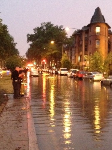
(WASHINGTON, D.C.) — To mitigate flooding and sewer backups in the Bloomingdale and LeDroit Park neighborhoods, Mayor Vincent C. Gray and DC Water today announced a major new infrastructure project at the site of the former McMillan Sand Filtration Plant. The Northeast Boundary Neighborhood Protection Project is a product of the Mayor’s Task Force on the Prevention of Flooding, and will be built in three phases between now and 2022.

Mayor Gray established the task force in late August and named City Administrator Allen Y. Lew and DC Water General Manager George S. Hawkins as co-chairs.

“I asked the Task Force two basic questions,” said Mayor Gray. “The first is why the long-term solution to this historic problem was still more than a decade away. The second is whether anything more could be done in the interim. This project answers both questions. I applaud the Task Force and DC Water for developing it, and I want the residents of the affected communities to know that relief is on the way. It will be meaningful, and it will come soon.”

Continues after the jump. (more…)


In early Nov. we noted the cycle track was looking good, if slightly confusing at times.

From a press release:

Mayor Vincent C. Gray, District Department of Transportation (DDOT) Director Terry Bellamy, the Washington Area Bicyclist Association (WABA) and other local bicyclists today cut a ribbon to officially open the new separated bike lane on L Street NW. The celebration was held at the intersection of L Street and 15th Street, where the new lane intersects with one of the District’s other cycle tracks.

“Here, where the L Street and 15th Street bike lanes cross paths, you can see a new transportation network taking shape – one that treats cyclists with respect and concern for their safety,” said Mayor Gray. “I believe that having such a network is critical if we are going to meet our goal of becoming a more sustainable city by reducing our dependence on the automobile to get around town. Increasing safety for cyclists and growing the number of bike lanes in the District are parts of my One City Action Plan.”

The L Street NW cycle track runs east from New Hampshire Avenue to 12th Street and gives cyclists more protection from motor vehicles than a typical bike lane. A painted buffer and plastic bollards separate the bike lane from the through lanes for vehicular traffic on L Street, which is one-way eastbound. Vehicle loading, unloading or parking in the bike lane is not permitted at any time.

At intersections, the bike lane is painted green for greater visibility. Merge zones permit vehicles to carefully cross the bike lane to gain access to the left turn lanes.

“Every street is a little different, and we designed this bike lane with two primary goals in mind: to protect cyclists as best we could from turning vehicles, and to ensure we did not severely degrade the level of service for other traffic in this busy corridor,” said Director Bellamy.

The District now has almost four miles of protected bike lanes, including the existing bike infrastructure on 15th Street NW and Pennsylvania Avenue NW.

“I think it’s no accident that we’re seeing a healthy increase in cycling in the District,” added Mayor Gray. “The safer you make cycling, the more people will choose to bike.”

DDOT plans to install another cycle track on M Street NW next year. It will parallel the L Street lane and serve westbound bicycle traffic.


From DDOT:

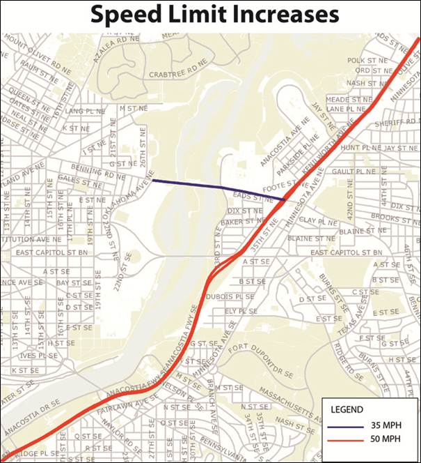
Mayor Vincent C. Gray today announced that he has ordered an emergency rulemaking to permit the District Department of Transportation (DDOT) to raise the speed limit on two District roadways. DDOT will raise the speed limit to 35 MPH on Benning Road, NE, between Oklahoma Avenue and Kenilworth Avenue (DC 295). DDOT will also raise the speed limit on DC 295 to 50 MPH so that the maximum legal speed is consistent from the Maryland border at Eastern Avenue to the southern border with Maryland on I-295 near the Wilson Bridge.

“These are roadways where we have previously studied the speed limits and can make changes immediately without significantly impacting safety,” Mayor Gray said. “We want drivers to respect our traffic laws, and in return we have to have realistic expectations of them that match the physical environment, while continuing to protect pedestrians and cyclists.”

The changes will take effect as soon as the emergency rulemaking has been completed and DDOT has changed the signage to reflect the new speed limits.

The agency will also continue its comprehensive study of speed limits on other roadways across the District.


Dear PoPville,

I was happy to see that DC started putting up signs on 11th Street (between W and U, at least) that restrict parking to certain times — which in theory should make it easier for residents to park during peak times. But I was confused/surprised by the times that are covered by the restrictions (see attached pic):

Monday thru Friday, 7am-8:30pm.

Having lived at 11/V for 4 years, the hardest times to find parking is weekday and Saturday evenings from 7p-midnight (nightlife), and Sunday from 11a-5p (church). These times are barely covered by the new regulations, per the signs. (Also, side-note: the church-goers tend to double park, park in bike lanes, park at bus stops, etc — and I’ve NEVER seen DC parking enforcement come around on a Sunday.)

Do you know what is up with this?

DDOT issued a press release that says:

The District Department of Transportation (DDOT) is scheduled to complete the implementation of the Enhanced Residential Permit Parking (ERPP) program in Ward 1 over the next few weeks. The ERPP program protects parking for neighborhood residents by designating one side of the street resident only parking from 7 am to 8:30 pm, Monday to Friday.

New signage for the ERPP program will be posted on blocks with traditional Residential Permit Parking (RPP) restrictions in ANCs 1A, 1B and 1C (ANC 1D opted out of the ERPP program). One side of the street will have RPP restrictions, and the other side will have enhanced restrictions.

RPP provides residents, with a residential parking permit, the ability to park on streets in their permitted area. Non permit holders may park in these areas for a maximum of two hours. By contrast, only residents may park on a curb with ERPP restrictions during the posted hours of enforcement, and an ERPP violation is a towable offence.

DDOT is implementing legislation sponsored by Ward 1 Councilmember Jim Graham and passed by the DC Council earlier this year. Crews will be working on an accelerated schedule to install about 2,500 new signs on approximately 550 neighborhood blocks included in the program. The installation will begin on or about November 17.

Anyone else think the program should be extended through the weekends?


Photo by PoPville flickr user sciascia

From a press release:

Mayor Vincent C. Gray and Deputy Mayor for Planning and Economic Development Victor L. Hoskins today announced the delivery of one of the Mayor’s key promises: a Five-Year Economic Development Strategy for the District. The strategy provides a roadmap for creating 100,000 new jobs and attracting $1 billion in new revenue for the District over the next five years.

The Five-Year Economic Development Strategy includes six transformative visions for the D.C. economy:

· Create the most business-friendly economy in the nation;
· Grow the largest technology center on the East Coast;
· Be the nation’s destination of choice;
· End retail leakage;
· Develop a best-in-class global medical center; and
· Become the top North American destination for foreign investors, businesses and tourists.

These visions are tied to 52 specific and achievable initiatives. District businesses and universities will play a central role in working with city government to implement these initiatives.

The Gray Administration has been busy at work since January of 2011 making concerted efforts to chart the course to a better District of Columbia. Notable milestones include:

· Launching $2 billion in long-stalled development projects, creating 4,600 construction and 7,600 temporary jobs;

· Placing more than 5,000 D.C. residents in jobs at 800 companies through creative initiatives like One City ● One Hire;

· Completing master plans for St. Elizabeths and Walter Reed;

· Completing 1,428 units of affordable housing and breaking ground on 1,655 more affordable units;

· Establishing the D.C. China Center in Shanghai to promote international trade and investment; and

· Leveraging a newly created business development team to facilitate economic-development opportunities like the consolidation of LivingSocial’s headquarters in the District, attracting Fortify.vc’s business incubator (The Fort) and launching Hub DC to help local businesses acquire federal contracts.

A Strategy Advisory Group helped develop the Five-Year Economic Development Strategy. Advisory group members included local elected officials, District government agency directors, university presidents, and leading employers in seven target sectors: 1) Federal Government and Federal Government Contractors; 2) Higher Education and Health Care; 3) Hospitality; 4) Professional Services; 5) Real Estate and Construction; 6) Retail; and 7) Technology.

The Five-Year Economic Development Strategy is available to the public on the website of the Office of the Deputy Mayor for Planning and Economic Development.


View More Stories